
| Distance | 9.72 mi |
| Elevation Gain | 515 feet |
| My Time | 3 hr 5 min |
| Difficulty | Easy |
| Nearest Town | Littleton |
| Food Nearby | Waterton Tavern |
Waterton Canyon
I did another easy hike today and tried out Waterton Canyon. This hike should be available for any skill level who is looking for a pretty hike next to a river. Today was a hot one but it was still very crowded with a lot of bikers, families with small kids, fishers, trail runners and a few walkers. One thing to note is that because of the native Bighorn Sheep population dogs are not allowed on this trail.
The canyon follows the Platte river in Littleton and technically is about as easy as it gets. It is also one of the best places to see wildlife close to Denver as there is a herd of Bighorn Sheep that stay around the area and usually make a cameo. One thing to keep in mind before we get started is that you will be exposed with no shade for the entire hike so make sure you slather on the sunscreen.
The Hike
You will begin with a walk on a partially paved road before getting onto a more dirt/pebble road for as long as you want to go. The beginning of the hike has the only trees that are really close to the trail and once you clear the trees, and about a mile into the walk, you find yourself next to the river and will follow it from then on. One thing to keep in mind, especially if you are coming with small children is that there are some Danger Noodles (snakes) on the trail.
Don’t let that discourage you though because the walk has some amazing views. The total distance to the main dam is over 12 miles round trip but there are plenty of places throughout the trail where you can stop off to get closer to the water or have a picnic and they even have pit toilets spread throughout the trail. Here is an example of what the hike looks like as as you get closer to the river.

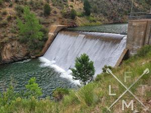
The First Dam
While you can always go as far as you want on the trail, Waterton makes it really easy to just turn around as you have a two lane road to walk on. One goal for a new hiker might be to get to the small dam in the middle of the hike. This dam is about 3 miles or so one way. It is a really nice man made dam and just past it the Platte spreads out and slows down and it is just really pretty.


About another mile after that is a small bridge you cross over where the river bends that is also a very pretty area. That is about as far as I made it this trip. It was mid-90’s and I didn’t have enough water with me to get up to the main dam which is just over 6 miles away from the trailhead. Around the 4 mile mark you also see a lot more bikes and a lot less hikers.
Bighorn Sheep
Lucky for me I was joined on the trail by some young Bighorn Sheep looking for a snack. They kept jumping down on the trail and back up to the rocks and followed me for a bit.
I also saw a bear climbing on the top of one of the cliffs thanks to some eagle eyed ladies who I stopped to chat with. It was my first time seeing a bear in the wild, and although it was pretty far away it was pretty cool to see.
If you do decide to ride your bike on this trail, please be careful of the animals. Here is some video I got and if you wait until the end you see a near biker/sheep collision.
I have some more videos of the sheep and of the river added to my Zen section of the is website if you are interested in that. Here are some stats from today’s hike.
Distance and Elevation
If you don’t have the AllTrails app you might want to check it out, I really love mine. It records your progress and is a great way to search for hikes that are nearby and gives you difficulty measurements. According to AllTrails today’s hike was around 9.72 miles and had a total elevation gain of about 515 feet including undulations. That put the high point at around 5,700 feet. I was also moving for a total of 3 hours and 5 minutes.
I am a Pro member of AllTrails and love it. If you are interested in the platform, please consider using my affiliate link for AllTrails. It gives me a small commission with no extra cost to you.
Effort
This really was just like a walk down a road and there wasn’t much extra effort for climbing over things or anything like that. According to fitbit.com here are my stats from today’s hike.

Terrain
The terrain is a dirt road with some paved sections at the beginning. While I saw some people in sandals and regular gym shoes, I went with hiking shoes. The first time I did this trail it was with gym shoes on and because of all the little pebbles on the dirt road my feet were suffering by the end.
Access
There is a relatively large (for a trail head) dirt parking lot that you can park at on Waterton road. There is a picnic area and restroom at the parking lot. Bathrooms and picnic areas are spread along the trail itself.
Wrap up
Waterton Canyon is a very easy hike with a small elevation gain spread out so the grade is really low. You follow a river for most of the time and are walking along a roadside. It is also a great place to see wildlife and would be a really nice starter hike for anyone looking to get some exercise. You do need to make sure you bring water with you.
I have walked here 3 times now and the same thing has happened each time. Its so easy to walk that it is also easy to lose track of how far you have gone and then you have to walk back! Make sure you keep that in mind and don’t go so far that you can’t get back to the car. It really is a very pretty walk and something that everyone should be able to enjoy as they can go as far as they like. Here are some more pictures of today’s hike.
After the hike I went to the Waterton Tavern for some lunch. Its a cool place with nice food, keep them in mind if you take the walk.
If you have a suggestion for a hike that you would like me to try, feel free to email me at fatmanlittletrails@gmail.com or you can follow me on the below social media platforms. I have also added this hike to interactive map that you can find here.


Any hike along water is ok with me!
Pingback: Waterton Tavern - Fat Man Little Trail
Pingback: Button Rock Dam/Sleepy Lion Trail - Fat Man Little Trail