
| Distance | 3.84 mi |
| Elevation Gain | 1594 feet |
| My Time | 2 hr 29 min |
| Difficulty | Hard |
| Nearest Town | Silverthorne |
| Food Nearby | Carlos Mexican B&G |
Mount Sniktau
Mount Sniktau is a 13,000 foot peak, or 13er, located on Loveland Pass near the US 6 exit off of I-70. While it isn’t statistically the most challenging it was big challenge for me and I finally got it finished after several attempts.
Heartattack Hill
I don’t know if it is really called Heartattack Hill but that is what I have taken to calling it as it almost caused me to have several heart attacks. HH is the initial hill from the parking lot because nature doesn’t believe in a warm up. It is brutal. It is straight up on a rocky dirt path. The path is consistently high 20’s to mid 30’s in grade with a max of around a 38% uphill grade! In just under a mile you will gain 1000 feet of elevation.
The good news is that this is by far the most difficult part of the hike. The bad news is this is the most difficult part of the hike and it comes right off the bat and starts at nearly 12,000 feet so it will really get the heart going. Here is a view with my camera set level to show you the grade up the hill.

The Top Junction
After making it up Heartattack Hill you will be rewarded with a really nice view of the surrounding areas. There are also two very large cairns on either side of the landing and trails that go to right or left. The cairns are large enough that I saw people sitting behind them as some makeshift wind blocks.
To continue to Mt. Sniktau you will want to take the trail to the left and head north. The trail to the right takes you to Mt. Cupid and Mt. Grizzly and the truly brave soles can even take that to Grays and Torreys.

Continuing to the left on the way to Sniktau the path leads you down a saddle and up another hill. As you near the top of this hill the trail becomes rocky and splits into two. The first trail goes straight up the mountain while the secondary trail goes to the west around the hill before going back up towards the top.
I took the western trail which seemed a bit easier. Both of these trails are through a boulder field and the footing is that of walking over rocks so take your time.
False Summit
Not sure if it was a false summit or just wishfull thinking but the top of this hill is not Mt. Sniktau like I thought because I didn’t look at my map. Instead it is just another spot with some nice views but Mt. Sniktau still remains a little ways to your north.
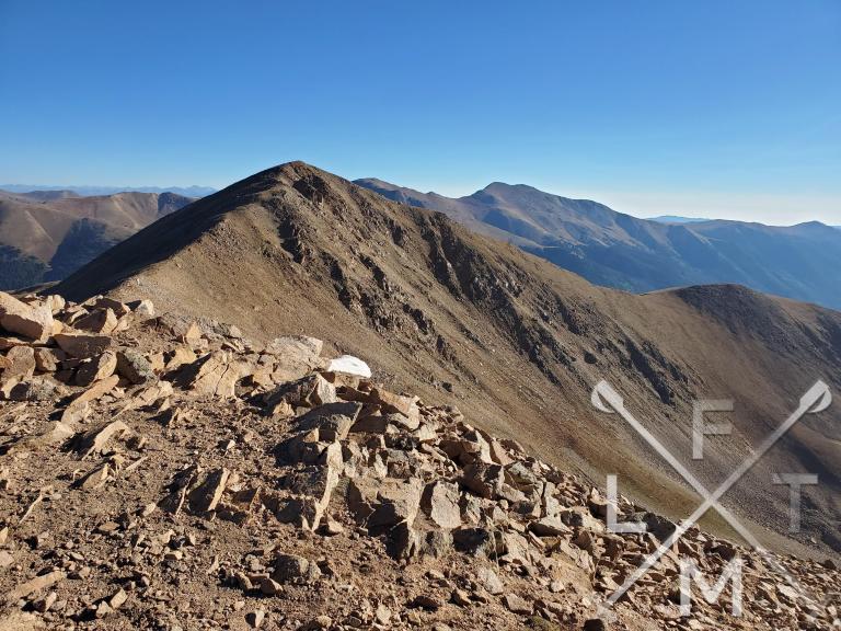
The trail to Sniktau is starts by walking over another boulder field from the top of this hill and then across the ridge-line to get to the peak. This ridge-line isn’t as bad as the first saddle that you walked over and the peak is only about a half mile away at this point. There is also this great view of a little pond that is down in the valley.

Mt. Sniktau
The last push up Mt. Sniktau again is a bolder field but the elevation gain isn’t as bad as the middle hill. The footing is a little rough though so again make sure you take your time. The peak is amazing with a lot of space. There was 7 of us and a couple of dogs and all had space to enjoy the views and relax a bit. The peak is officially at 13, 240 feet above sea level as well making it a “13er” (my first!)
For me it was special because it was a long time coming from the first time I decided to try it until actually finishing it. I really enjoyed my time up top.


The Return
Remember how steep Heartattack Hill was? Well it is just as steep going down and the loose dirt and rocks makes for very slow going. I have seen a couple of people slip and fall on my different trips to the mountain so be very careful while descending down.
Distance and Elevation
If you don’t have the AllTrails app you might want to check it out, I really love mine. It records your progress and is a great way to search for hikes that are nearby and gives you difficulty measurements. According to AllTrails today’s hike was around 3.84 miles and had a total elevation gain of about 1594 feet including undulations. That put the high point at around 13,224 feet. I was also moving for a total of 2 hours and 29 minutes.
I am a Pro member of AllTrails and love it. If you are interested in the platform, please consider using my affiliate link for AllTrails. It gives me a small commission with no extra cost to you.
Effort
This is a tougher hike especially at the beginning with some really tough grades. It was almost a walk 10 steps, rest, walk 10 steps pace. I took a little extra time at the top today so the hike was broken down into two recordings on my Fitbit.


Terrain
The first hill that you will hike up is very steep with loose rock and dirt as the trail surface and it can get very slick especially coming down. The top of both hills you have to climb at the top are mostly large rocks that you will need to walk over. The trails on the saddle are mostly dirt and easy to navigate. I would strongly suggest good hiking shoes or boots and poles.
Access
There is a parking area on the top of Loveland pass near the Loveland pass sign. The lot can fit maybe 15 cars. There is another lot about a quarter mile to the south that also fits about 15 cars. There are no bathroom facilities at either location.
Wrap up
This hike was a real challenge, especially getting up that first hill with a lot of breaks along the way. The views at the top are pretty nice and pretty much 360 degrees of mountain range. It really isn’t a very long hike neither does it have a huge incline involved with it but it is short and steep and it was a major goal of mine to finish this hike.
Maybe because of the extra attempts but I was more proud of finishing this hike than I have been on some longer hikes with larger elevation gains. While other trails are forest or mixed trails this one really feels like you are just climbing a mountain. You are totally exposed the entire walk and it is just you against the hill. I’m sure it isn’t nearly as challenging for someone in better shape but for me this was a nice accomplishment.
I have added this hike and all of my hikes on my interactive map that you can find here. If you have any suggestions for hikes or any other comments feel free to email me at fatmanlittletrails@gmail.com or you can follow me on any of the below social media platforms. Happy Hiking!


Congratulations Greg! Showed true grit on this one!
Pingback: Fatman's Favorites: Hikes - Fat Man Little Trail