| Distance | 3.35 mi |
| Elevation Gain | 253 ft |
| My Time | 1 hr 29 min |
| Difficulty | Easy |
| Closest town | Castle Rock |
| Food Nearby | Angie’s |
Mitchell Creek Canyon
Mitchell Creek Canyon in Castle Rock is very similar to Castlewood Canyon but on a smaller scale and was a surprisingly nice hike for me.
The start of this hike is actually in a neighborhood on a paved sidewalk so I wasn’t holding out much hope. About a third of a mile on the paved path there will be sign and a dirt path that will be the real beginning of the hike. The paved section is actually full of wildflowers and some nice plants and trees so it wasn’t all bust either. There were also a ton of baby bunnies running around today.

The Canyon
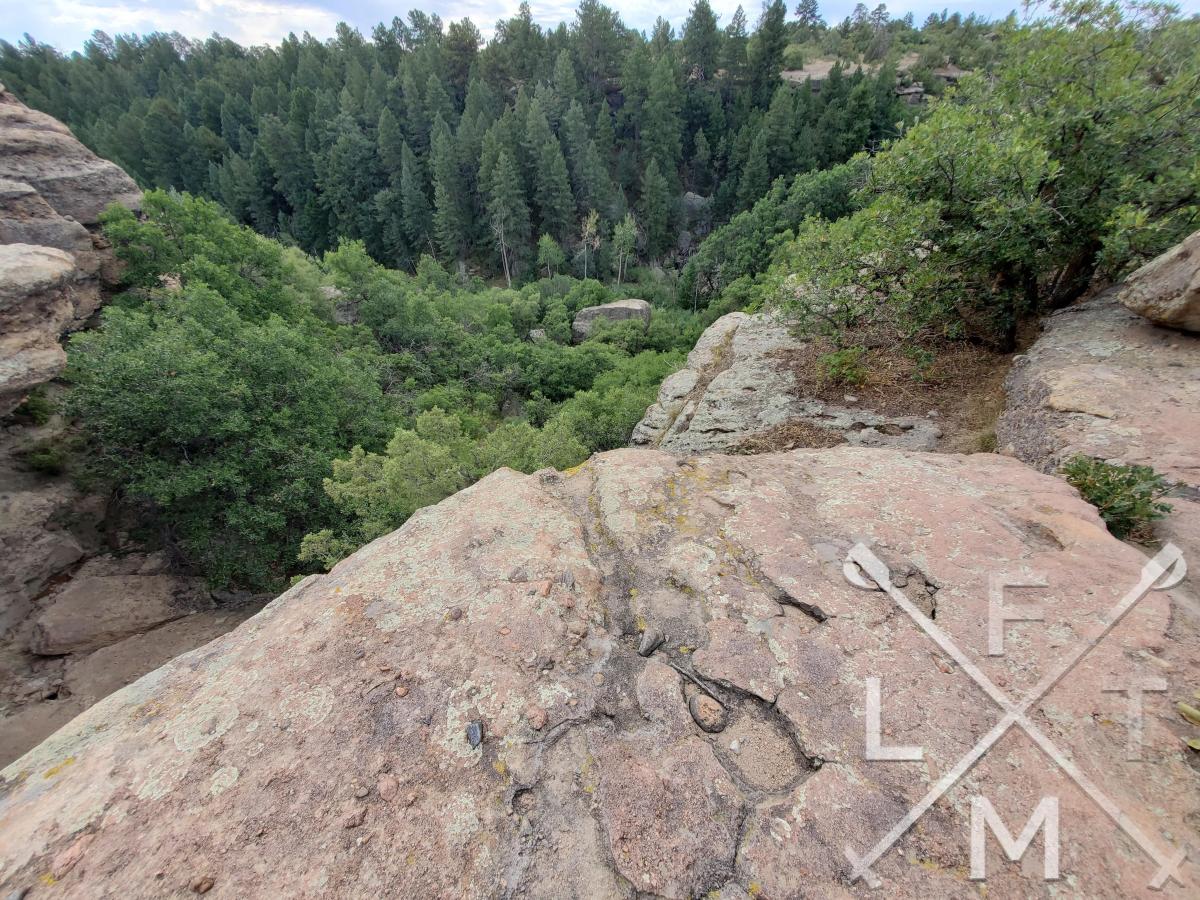
The canyon trail gets a lot more rocky and you start on a lower level with rock walls on either side of you. As you progress down the path you will have to climb up over some rocks to get onto the upper shelf of the canyon. Once you get to the higher level the views get better but the footing is all rock. It is also a little challenging to keep to the trail. There are Cairns throughout the path but I found myself missing them quite a bit.
At this point you are just walking on the high shelf and making your way towards the mouth of the canyon. The views really are nice for a short trail that wasn’t very busy.

The finish to the hike is at the junction with Chucks Loop trail. According to All Trails it looks like there is another parking lot at the Chucks loop trailhead. Starting there might make this more of a complete hike. I also found it easier to follow the cairns on the way back from this, northern side, of the trail although the cairns lead you away from the edges where all the nice views.
Distance and Elevation
If you don’t have the AllTrails app you might want to check it out, I really love mine. It records your progress and is a great way to search for hikes that are nearby and gives you difficulty measurements. According to AllTrails today’s hike was around 3.35 miles and had a total elevation gain of about 253 feet including undulations. That put the high point at around 6, 552 feet which was actually at the trailhead. I was also moving for a total of 1 hours and 29 minutes.
I am a Pro member of AllTrails and love it. If you are interested in the platform, please consider using my affiliate link for AllTrails. It gives me a small commission with no extra cost to you.
Effort
For a simple hike there were moments where this was a little challenging. Mostly in the footwork around the rocky terrain. I forgot to charge my Fitbit so I only have an estimate on steps today. I would say it was close to 9000 steps to finish the hike. I’ll do better next time.
Terrain
There is a mix and match of terrains on this trail. If you park in the neighborhood then you will start on a paved path before transitioning to a harder packed dirt trail. As you get deeper into the canyon you end walking mostly on the top of huge rocks with dirt trail connecting them. While not overly difficult footing it is a touch challenging to make sure you don’t take a bad step.
Access
The entrance to the trail is actually in a neighborhood on Wagon Wheel drive. There is no parking lot or restroom facilities. I did notice that the end of the trail on the northern side it connected to a trail called Chuck’s Loop and there may have been more parking there.
Wrap up
Overall I was really surprised with this hike. It actually turned out to be more challenging and had better views than I was expecting. This might be a good hike if you are trying to learn how the cairn system works for navigation. I got “lost” trying to follow them but when you are walking on the rocks on the top ledge there really is no discernable trail so it is good to follow them. For me this was a moderate hike as the footing and trail following are a bit challenging.
I have added this hike and all of my hikes to the interactive map section you can find here. If you have suggestions for a hike you would like me to try or any other comments feel free to email me at fatmanlittletrails@gmail.com or you can follow me at any of the below social media platforms. Happy Hiking!