
| Distance | 3.8 mi |
| Elevation Gain | 650 feet |
| My Time | 1 hr 37 min |
| Difficulty | Moderate |
O’Fallon Park
I didn’t have a ton of time and wanted to get a shorter hike in today and made my way to O’Fallon park. O’Fallon is part of the Bear Creek series of parks around the Evergreen area that include Lair O’ Bear and Corwina as well.
I have driven by several times and this park is usually completely full but on a Tuesday morning at 7:15 there was plenty of parking and only a few people on the trail. I parked near the picnic area and the West Ridge Trailhead and made a loop by going West Ridge – Bear Creek – Meadow View back to West Ridge.
West Ridge Trail
One day I’ll find a trail that doesn’t give me all of the elevation right off the bat. Today was not that day. While the total elevation gain for the hike is only around 650 feet, 300 of those feet are in the first half mile. None of the grades are overwhelmingly steep but they are consistent right from the start. My calf muscles were burning pretty good and I actually had to take a couple of stops to let them loosen up in that first half mile.
The good news for you wild flower lovers, there are a ton in this first section of the trail. If you notice an extra amount of flower pictures in today’s gallery it is because I needed that many stops on my way up the starting hill. I think this was my favorite spot though as the entire field was covered in these.

The rest of this section of the trail is in a forested area and is shaded. There looks to be a creek bed that you are walking next to but it was dry at this point in the summer. A little past the meadow with the flowers you will walk by a giant hole next to the trail.

The hole was about 4 feet deep and looked like an old sink hole or possibly the remnants of the root system of some tree that had fallen a few years back. The hole means you are pretty close to the section of the trail that levels off.
The Junction
Once the trail levels off you come to the junction between the Meadow View trail and the West Ridge trail. I stayed on West Ridge at this point and I think the views are much better on this trail. If you look really closely at the hill top on the right you can see the Fatman’s future house.
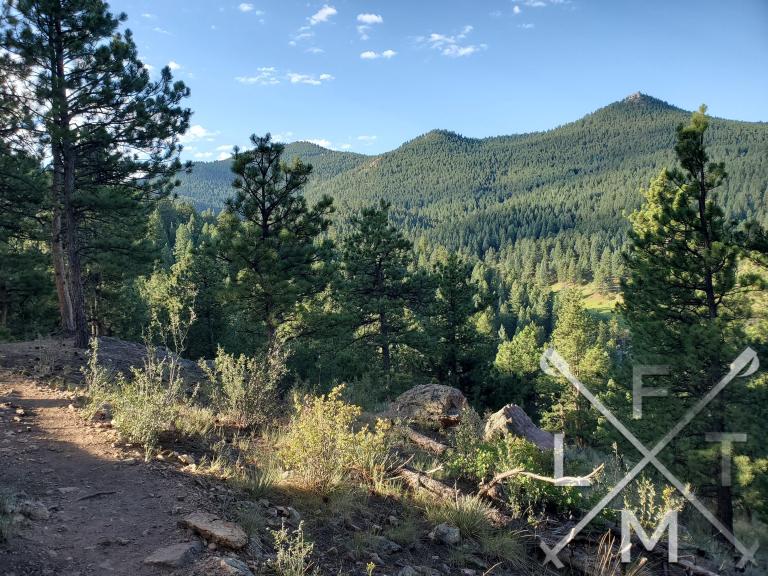
Once you get to this point on West Ridge the trail is relatively flat and really easy to deal with. It is mostly wide and hard packed dirt with the occasional rock. This is actually a lovely walk from this point on with no real elevation to have to deal with. After the hill views you will cross to see a large meadow and then intersect with Bear Creek Trail.
Bear Creek Trail
You can take Bear Creek as far as you like at this point as it connects several parks are runs for several miles. If you decide you want to get back to your car I would suggest taking a left(east) which will loop you back towards the park. Bear Creek is really easy here. You will come out of the trees and loop around and see some houses and have a really nice view back towards the entire park. You can stay on BC and loop back to West Ridge or you can take Meadow View which is what I did. There are also some nice flowers on this stretch of Bear Creek as well but you are exposed so watch out for the sun if you go around noon.
Meadow View Trail
I found Meadow View as a bit of a misnomer. You actually spend most of your time back in the forest on this trail with not too much of a view of the meadow. As you get back to the junction you passed earlier it opens up and you get some more views.

This trail is really easy as well with little elevation gain. It does narrow a bit through the forest but the trail is easy to follow and a good hard packed dirt with little rocks or roots to deal with. This trail is only about a half mile long and then you hook back up with West Ridge for the trip back to the parking lot.
Elevation and Distance
If you don’t have the AllTrails app you might want to check it out, I really love mine. It records your progress and is a great way to search for hikes that are nearby and gives you difficulty measurements. According to AllTrails today’s hike was around 3.8 miles and had a total elevation gain of about 650 feet including undulations. That put the high point at around 7,350 feet. I was also moving for a total of 1 hours and 37 minutes.
I am a Pro member of AllTrails and love it. If you are interested in the platform, please consider using my affiliate link for AllTrails. It gives me a small commission with no extra cost to you.
Effort
After the challenging start this turns into a pretty easy walk. Here are the stats from my Fitbit from today’s hike.

Terrain
The Terrain is mostly hard packed dirt that is pretty easy to manage. There are an occasional root or rock coming up from the dirt but nothing that is too difficult to manage. The trail does narrow to around 8 inches wide in a few stretches towards the beginning and around the top there is one area that you need to walk on some small rocks. Overall it is a relatively easy trail to navigate.
Access
O’Fallon park is located on Rte. 74 between Ideldale and Kittredge. It is on the south side of the road just past the second Corwina Park pull-off if you are coming from Denver. When you turn off of 74 it will be onto a dirt road with 3 separate parking areas. There is a pit toilet near the last parking area.
Wrap Up
This is a nice little hike if you are looking to get some exercise. I’m going to rate it as moderate because of the opening incline but it is pretty easy after that. It might be a good place for your first moderate hike!
I know that the park is usually really crowded but I didn’t see many people on it around 7 am on a Tuesday morning. The most difficult part is definitely the first half mile or so. Then it flattens out to a nice relaxing walk with some great bird watching and flower spotting. There is also a really nice mix of forest and open space so you can find shade if you need to but still get nice views of the surrounding area. I did see a small dear in the woods on the way back. Lets see if you can see it in the gallery below!
If you have a hike you would like me to try feel free to email me at fatmanlittletrails@gmail.com. Or you can follow me on any of the below social media platforms. I have added this hike as well as all the hikes and restaurants to my interactive map that you can find here.
After the hike I went to the Blackbird Cafe and Tavern for brunch and the setting was as good as the food.


Pingback: Blackbird Cafe and Tavern - Evergreen - Fat Man Little Trail