
| Distance | 3.91 mi |
| Elevation Gain | 1506 ft |
| My Time | 2 hr 30 min |
| Difficulty | Hard |
| Closest Town | Boulder |
| Food Nearby | Chautauqua Dining Hall |
The Royal Arch
The Royal Arch Trail in Chautauqua Park in Boulder was a great hike full of amazing views. It will test your endurance with steep inclines along the way.
Chautauqua Trail Loop
There are a couple of ways to get to the Royal Arch Trail. The more direct way is to go up the service road that is part of the Bluebell trail. I decided I wanted to get a bit more views as it was my first time at the park so I took the Chautauqua Trail to begin.
The Chautauqua Loop goes right up the middle of the park and has some really amazing views of the Flat Irons.

The views had me in a bit of a trance as I kept drifting closer and closer to the rocks. The trail through the meadow has a pretty consistent 15% grade on a wide trail with plenty to look at.
About a half mile into the hike you will enter a more wooded area with more views mixed between trees and mountainside.

In the woods at the .7 mile mark you will come to a junction with the Bluebell-Baird trail. To get to the Royal Arch trail you will take that trail to the east (follow signs to continue the Chautauqua Loop). Don’t worry, I will head back and tell you about the other trails some other time!
Another .2 miles through a heavily wooded area will get you to the Royal Arch trailhead. You will also see the Bluebell Shelter here so you will know you are in the right spot.
Royal Arch Trail
The Royal Arch Trail starts off as a nice and easy trail through the woods. You will come to a junction with the Flatiron Loop trail but stay on Royal Arch. About .4 miles of nice lovely walking through the woods you will come the hard part.
Stairway to….
Nobody told me that the Royal Arch trail is essentially a half mile long stairway of rock. Led Zeppelin are liars. Mile long snow covered staircases do not end in heaven, they do end with great views though!

So now its time to take the stairway. This will be your hike for about the next half mile although it feels like it is a lot longer than that. For you winter hikers out there, I wore spikes on these stairs which was tricky because there was some snow, ice and exposed rock. The spikes were great on the snow and ice and made me feel comfortable. They did get a bit slippy on the exposed rocks though so be careful.
The stairway did lead to some nice views and the entire part is the trees so not much sun to get you to sweat even more. There are a couple of switchbacks but mostly you will be walking on this until you make it to Sentinel Pass.
Sentinel Pass
Ok this was cool. 1.7 miles into the hike you will come to this pass. The pass is the end of the stairway and the start of more difficult terrain so this is a good place to catch your breath and prepare yourself for the rest of the hike. Only .2 miles left from here but they are challenging.

While you gained about 400 feet on the half mile of the stairway you are about to give some back. Immediately after Sentinel Pass you will head down a steep area. In a tenth of a mile you will descend 150 feet before climbing again. This is some tricky footwork and took me a long time so make sure you are comfortable before moving on.
After your descent you will head up a looser stairway and gain 300 feet of elevation in the next tenth of a mile so it gets pretty steep. Again be careful on your footing.
Royal Arch
Finally the prize. After a particularly steep hike you have made it to Royal Arch. It really is stunning.
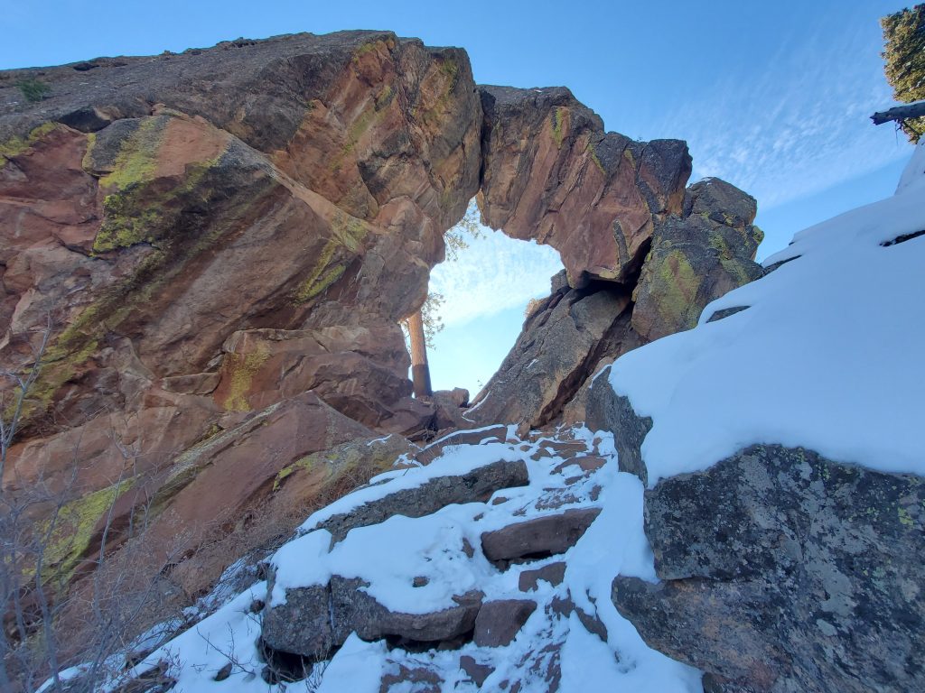


You can make it right up to the arch itself. If you believe in gravity like I do, you might not spend too much time under the arch but I am sure it is safe. Some of the best views also come when you are at the arch and look back towards the flatirons.


You can also see all of Boulder from here if you are more into city views. (photo in gallery at bottom)
After the arch it is time to make it back. The steep steps took just as long if not longer on the way down. On the return, to finish the loop, I took Bluebell back towards the parking lot. This is a very wide service road and makes for a nice walk after being so careful on the stairway. Make sure to turn around to get some great views of the Flatirons!

Elevation and Distance
If you don’t have the AllTrails app you might want to check it out, I really love mine. It records your progress and is a great way to search for hikes that are nearby and gives you difficulty measurements. According to AllTrails today’s hike was around 3.91 miles and had a total elevation gain of about 1506 feet including undulations. That put the high point at around 6,958 feet. I was also moving for a total of 2 hours and 30 minutes.
I am a Pro member of AllTrails and love it. If you are interested in the platform, please consider using my affiliate link for AllTrails. It gives me a small commission with no extra cost to you.
Effort
This one was a challenge. A lot of elevation gain in a short distance but the views made it worth it! The hardest part is definitely the giant “stairway”. Here is the step count from my Fitbit.

Terrain
The lower section of this hike is a solid trail that is plenty wide. In fact the return on the Bluebell Trail was a service road. The Royal Arch trail is narrow with a lot of “stairs” in the rock. These are solid rock which were slick with the snow and ice cover. Closer to the Arch there is some rock walking that is necessary as well. I would suggest a good pair of hiking shoes.
Access
The hike begins at Chautauqua Park located on Baseline and 9th in Boulder. There are about 30 parking places but they fill up quick. A free bus service is available and recommended on weekends and in the summers. This is a very busy and popular park. There were a couple of port-o-potties available.
Wrap Up
So I liked this hike and didn’t like this hike. To start out the views are absolutely stunning. I will be returning to this park a few times. But my oh my is that incline a challenge if you aren’t ready for it. I think the winter footing made me a little nervous so I couldn’t enjoy it as much.
That being said, I think this is actually a great place to visit in winter. The park and the hike were beautiful with a few inches of fresh snow. Just make sure you are prepared for how steep and challenging parts of the hike can be.
Overall I will say that I really enjoyed my time. Once the I came down and the nerves settled down I was really impressed with what I had seen and done. I would highly suggest this hike if you are confident in your skills and willing to handle the elevation gains.
I have added this hike and all of my hikes to my interactive map page you can find here. If you have a suggestion or comment feel free to email me at fatmanlittletrails@gmail.com. You can also follow me on any of the below social media platforms. Happy Hiking!


Pingback: Chautauqua Dining Hall - Fat Man Little Trail