
| Distance | 6.83 mi |
| Elevation Gain | 1,473 ft |
| My Time | 3 hr 13 min |
| Difficulty | Moderate |
| Closest Town | Buena Vista |
| Food Nearby | Eddyline |
Ptarmigan Lake Trail
The Ptarmigan Lake trail is moderate hike with a steady incline that brings you to a beautiful alpine lake with great views of the Collegiate Peaks. You don’t have to be super advanced in to try this high altitude lake hike that shows some of the best Colorado hiking has to offer.
Getting Started
The Ptarmigan Lake Trail has its own trailhead and parking area towards the top of Cottonwood Pass above Buena Vista, Colorado. The trail starts at about 10,665 feet but luckily your car does a lot of the heavy lifting.
You will begin crossing a small stream in a heavily wooded section of the San Isabel National Forest. Before too long you will come to a large rockslide section. This rockslide doesn’t seem too recent as there is a pretty defined way to cross it.

While the rock can look intimidating it also gives you the first really good views of the surrounding mountains. Just make sure you pay attention to where you are stepping and not on the views!

The Second Slide
After making it past the first rock slide you will be back in the woods on a very well defined trail. The woods give a lot of cover and shade for a higher elevation hike which is nice. About a mile total from the start you come to the second rockslide. This one is shorter and kind of circles around a gully.

This rockslide isn’t nearly as long as the first one and is a little bit easier to navigate. The trail is more well defined and the rocks are mostly cleared off of it. The views from this one are just as nice as the first one though.

After the second slide it is back into the woods. The trail will stay covered and with a pretty consistent 6-10% for most of the time that you are in the woods. When I went there were several small streams and wildflowers popping up all around.

Lower Ptarmigan Lake
About a mile and a half from the second rockslide the trees will start to clear out and you will find yourself with a small lake below you and a pond next to you. While there wasn’t really a dedicated path to the lower lake, Lower Ptarmigan Lake, there were still several people who decided to make the trip down to it.
After the lower lake the hike takes on more of an alpine feel. The trees become sporadic and you lose your canopy cover. The trail starts to get a bit steeper here as well. The views looking back down toward the Collegiate Peaks is simply stunning. I believe this is Mount Harvard in the distance.

In mid-June when I did this hike there was also a lot of water on the trail in these higher elevations. I had to cross a few “streams” that were running down the trail and was very happy to have my waterproof Kodiak Boots on!
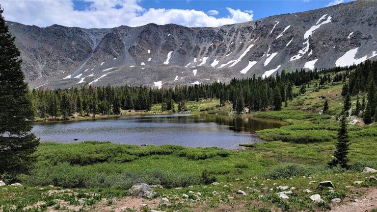
Ptarmigan Lake
The final push to Ptarmigan Lake is the most challenging. The trail narrows and becomes much steeper. The winds also picked up the closer to the lake I got. This could have been just a windy day scenario but I have been to enough of these high elevation lakes to know that it is pretty common to be windy.
The lake itself is a decent size and surrounded by mountains. It was stunning. There was also plenty of room around the lake to support about a dozen groups of us who were up there at the time. Several people were fishing the lake and others were having picnics or just enjoying the views.

If you are looking for a lake above 12,000 feet and are new to Colorado hiking this might be a good lake to attempt. The trail is challenging but not terribly difficult and the views are pretty amazing.
Video
I have put together a couple of videos for your viewing pleasure. The first one is a narrative of the hike and a recap of this post.
This second video is a time-lapse version of the hike that I call my Hikers Edit. I think that I have gotten the speed to a better place than some of the earlier ones so hopefully it is less bouncy. I hope you enjoy them. If you do you can always subscribe to my YouTube channel for free and get the fastest updates on new videos.
Elevation and Distance
If you don’t have the AllTrails app you might want to check it out, I really love mine. It records your progress and is a great way to search for hikes that are nearby and gives you difficulty measurements. According to AllTrails today’s hike was around 6.83 miles and had a total elevation gain of about 1,473 feet including undulations. That put the high point at around 12,138 feet. I was also moving for a total of 3 hours and 13 minutes.
I am a Pro member of Alltrails and love it. If you are interested in the platform, please consider using my affiliate link for AllTrails. It gives me a small commission with no extra cost to you.
Effort
For being a hike to 12,000 feet this hike wasn’t all that challenging. There was a pretty consistent 6-10% grade so it was like walking up a ramp for most of the hike. The end section to get to the lake did get more strenuous in the incline but nothing that was completely overwhelming.
Terrain
The trail is in mostly good shape. There are two sections of rock slide that is a little trickier on the footing but other than those the trail is easy to follow and well defined. Most of the hike is also in the trees which gives you a bit of shade. The final approach to the lake is out of the woods and completely exposed to the wind and sun so make sure you are prepared for that. In mid-June there were also a few streams and some trail under shallow water.
Access
The Ptarmigan Lake Trail is a small trailhead that is well labeled towards the top of Cottonwood Pass (Colorado 306). There are parking spaces for about 6 cars and I would say another 5 or 6 can park on the side of the road. There are pit toilets available at the trailhead.
Wrapping up Ptarmigan Lake Trail
I really enjoyed this hike. It wasn’t too challenging and the views were absolutely amazing. It did get a bit crowded during the week and I found the last spot to park in the lot so keep that in mind on your trip.
The hike itself was a steady but not overwhelming incline. There was a section at the beginning that might be a little rough for those of you who don’t like heights but most of the hike is through the woods and covered. When I went it was very windy at the lake but the views from the lake were great. I would highly recommend this hike.
I have added this hike and all of my hikes to my interactive map page that you can find here. If you have a suggestion or comment you can email me at fatmanlittletrails@gmail.com or follow me on any of the below social media platforms. Happy Hiking!


