
| Distance | 6.08 mi |
| Elevation Gain | 1,398 ft |
| My Time | 2 hr 36 min |
| Difficulty | Moderate |
| Closest Town | Conifer |
| Food Nearby | Conifer Cafe |
Meyer Ranch Park
I headed out to Meyer Ranch Park on what turned out to be a cool overcast and somewhat gloomy day. But the hike was anything but gloom. This hike may be the perfect place for anyone living in a concrete jungle who needs a relaxing return to nature.
This hike is relatively close to Denver right off of 285. The hike itself is more or less a walk in the woods. The beginning starts as what seems like an old service road before splitting off to some more typical foot paths. The paths are very easy to navigate. Unlike the grueling Bergen hike I did earlier in the week, Meyer has short bursts of elevation and then longer flat paths. Think of the first time you get on the treadmill after the holidays and set it to the “hills” function. After the first mechanical “hill” of the treadmill you quickly drop that difficulty setting back from 8 to 2 and have a nice enjoyable walk. That is what Meyer feels like. You get past a few inclines and a few rocky patches and then just enjoy.
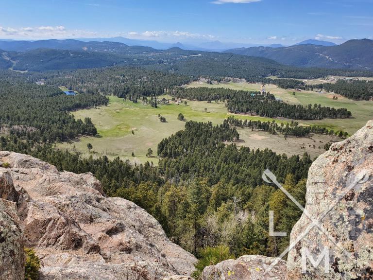
Legault Mountain
The best part for me was a little side trail that I accidentally got on while I was letting my mind wander. The path is unmarked but showed up on my hiking app so I followed it and ended up climbing to the top of Legault Mountain. This trail was more challenging and the elevation was greatly increased so if you don’t like hills you may want to stay off this one. The views were sensational. There were a handful of people at the top but enough room to see this:
Overall this is a very quick, easy to navigate hike through a heavy wooded area that might be exactly what someone needs to get away quickly.
Elevation and Distance
If you don’t have the AllTrails app you might want to check it out, I really love mine. It records your progress and is a great way to search for hikes that are nearby and gives you difficulty measurements. According to AllTrails today’s hike was around 6 miles and had a total elevation gain of 1398 feet.
I am a Pro member of AllTrails and love it. If you are interested in the platform, please consider using my affiliate link for AllTrails. It gives me a small commission with no extra cost to you.
If you have a suggestion for a hike that you would like me to try, feel free to email me at fatmanlittletrails@gmail.com or you can follow me on the below social media platforms. I have also added this hike and all the hikes to the interactive map that you can find here.
Here are the views from the rest of the hike.


For this weeks “Last Words”, I give you what those in the television business call a tease:
After the hike I had lunch at the Sit N Bull Saloon. If you are around the Indian Hills area, check them out.