
| Distance | 10.57 mi |
| Elevation Gain | 1722 feet |
| My Time | 4 hr 20 min |
| Difficulty | Moderate |
| Closest Town Twin Cedars | |
| Nearby Food |
Raleigh Peak Trail
The Raleigh Peak Trail, which doesn’t actually take you to Raleigh Peak is a portion of the Colorado Trail Segment 2 that is a moderate trail through burn scar and woods. If you like a good workout and the uninhibited views that a burn scar can provide this might be the hike for you.
Getting Started
Before you even get on the hike you will already be surrounded with some amazing views. To get to the trail you need to drive down North Platte River Road which hugs the Platte River and is really a nice little drive.
To start, you will cross over the Cudy Gaskill Bridge over the Platte River. There are a few places along the river that you can get nice and close and on my way back I saw a few people fishing on the banks. Here is a view from bridge.
The bridge and a short walk along the river bank is about the last level ground you will be on. The hike begins its incline almost immediately with a series of switchbacks that climb to the top of the first hill that you can see from the car.
While the inclines aren’t too dramatic and top out in the 20% grade range, you will need to climb about 400 feet in just under a mile.
At the top you have a couple of options. If you are like me and get confused easily you are likely to continue going straight when you get to the top of this first hill. If you go straight, there is a really nice ridgeline that you can walk across that gives you some really nice views of the area.

Unfortunately the ridgeline is not the proper way to go if you want to to do the actual hike. I would suggest doing it though if you have some time as the views are really nice.
The Burn Scar
When you reach the top of the first hill if you turn to the right and swing around the hillside you will be on the correct path. From this point on you are walking through burn scar and are completely exposed to the elements so make sure you are prepared for that.
Burn Scars aren’t really my thing. I know some people like them and they do give you some nice unobstructed views of the surrounding area’s but I just don’t love them.
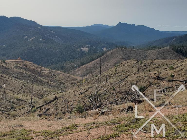
The burn scar runs about the next two miles. The trail is easy enough to follow and is a softer dirt path with a few small rocks but in general it is easy to navigate. So yep you just walk across the hillsides surrounded by some dead trees and big rocks. Luckily to break up the monotony I ran into some new friends.
Back to the Trees
Around the 3.5 mile mark you find yourself back into some tree cover and shade. The good part is that you have some cover, the bad news is you do lose the views of all the surrounding hills. I found the trail here a little challenging but I wasn’t sure why. I think it is because you are on a pretty steady incline but it tops in the 15% grade range and usually sits around 7-10%. What makes that challenging is that I didn’t really slow down. I just plowed through and then found myself taking some breaks and my legs getting really tired.
The Loop
I really don’t think that this trail is really a loop anymore. There was no trail to connect to the loop at all and I needed to go about 50 yards off trail to connect to a fire road. It was all correct according to the AllTrails app but it looked like it was referring to an older trail possibly. You may want to look at this as an out and back.
However. I think a majority of my enjoyment from this hike came from the fire road on the loop coming back. It started when I ran into this group.
After that standoff, or about a half mile onto the fire road, you will find yourself exposed again for the 2 miles of the loop back to the main trail. This is the one spot that the views really started to pick up as well. There was even a spot where you could see all the way to Pikes Peak (on a clearer day) but mostly you got some really good views of, what my 2nd grade cartography education, has me believe is actually Raleigh Peak.

One thing to keep in mind is that after about a half mile on the fire road it will split off and give you the option to go left into the woods or stay straight. Stay straight here and the road will eventually become less of a road and more of a trail and that is what will connect you back to the main trail.
Finishing up
When you connect back to the main trail you are still in the burn scar but only have a mile to get back to some trees, 2 miles to get back to the parking area. There is a small cut off that leads to what looks like an old mine and mill. This is marked by a large white column like rock. There isn’t much too it but some old equipment if you like that sort of thing.
Danger Noodle Warning
Always watch for snakes while hiking. I ran into this huge thing while I was about 50 feet from the bridge on my way back. Honestly I am just posting it because if I had to see I think you should have to see it too!
Time Lapse
I did this hike at another time and recorded this time lapse video. It is meant to give hikers a perspective of what to expect. If you enjoy this video make sure to subscribe to my YouTube channel. It is free and you will get the latest updates
Distance and Elevation
If you don’t have the AllTrails app you might want to check it out, I really love mine. It records your progress and is a great way to search for hikes that are nearby and gives you difficulty measurements. According to AllTrails today’s hike was around 10.57 miles and had a total elevation gain of about 1722 feet including undulations. That put the high point at around 7,601 feet. I was also moving for a total of 4 hours and 20 minutes.
I am a Pro member of AllTrails and love it. If you are interested in the platform, please consider using my affiliate link for AllTrails. It gives me a small commission with no extra cost to you.
Effort
While not technically challenging at all there is a consistent uphill angle for the entire first half of the hike. It got me a bit tired. Here is the step count for the hike from my Fitbit.

Terrain
This hike was mostly soft dirt with a bit of small rocks thrown in. There really weren’t too many large rocks or roots to deal with. The biggest issue was the burn scar and being completely exposed for a long portion of the hike. While the dirt is pretty easy to handle, I would suggest hiking shoes for the uphill sections with the dirt.
Access
The trail head is part of the Colorado Trail and is located on North Platte River Road. There are several places to park on North Platte River Road but you will look for the area with the bridge over the river. There are about 15 parking spots and there is a pit toilet on site.
Wrap up
This hike was a nice workout and had some good moments but not my favorite. For a majority of the hike out you are looking at mostly burn scar. It does have some really nice views of the surrounding area though.
While I didn’t find the trail terribly challenging technically it did have a very consistent elevation gain. It was a smaller gain and sometimes it was hard to even notice it but it really did begin to wear down my legs.
The last point is that this is a large chunk of segment 2 of the Colorado Trail so I’m sure a lot of people will take the trail for that reason. If you aren’t doing it for that reason you may want to look at Pine Valley Ranch instead. It is a similar hike in a similar area but I think the views are just a touch better.
I have added this trail and all of the trails on my interactive map that you can find here. If you have any suggestions or comments feel free to email me at fatmanlittletrails@gmail.com or you can follow me on any of the below social media platforms. Happy Hiking!
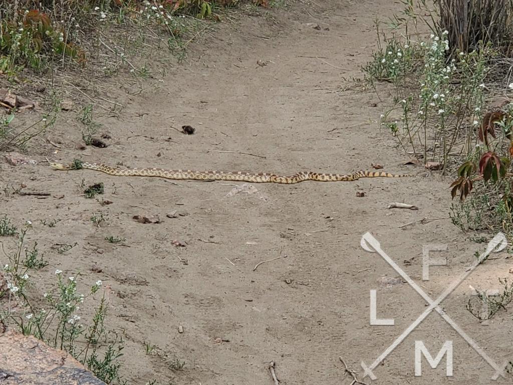


I guess those deer are used to hikers because they almost seemed to be posing for your pictures:) But the snake just seemed to be claiming his road, you must have won the standoff because here’s your post!