
| Distance | 12.65 mi |
| Elevation Gain | 1762 feet |
| My Time | 4 hr 27 min |
| Difficulty | Moderate |
| Nearest Town | Pine |
| Food Nearby | Rocky Mtn Wraps |
Pine Valley Ranch
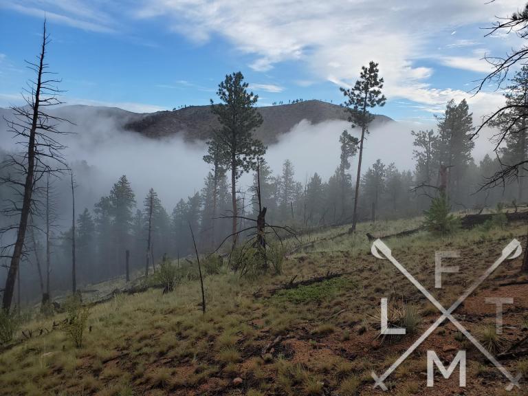
I’m having a week of repeat hikes it seems and today I repeated Pine Valley Ranch. There is a bigger gallery of the hike on the previous post. Today I added an extra loop so I decided to make a new post. Also today there was a cloud sitting over the park that gave it a really cool vibe for me and my friend Alex. It was her first time in the park and she seemed to really enjoy the day as well.
The Lake Area
There is a parking area that is only a few steps from Pine lake and the North Fork of the South Platte River. There were quite a few people that were enjoying the picnic area or were fishing on the bank of the lake as we finished our hike. The river was running rather high and fast today so I didn’t see anyone around that.
There is a really nice trail that loops around the river and the lake. We took it to start and finish the hike today but ended up jumping off for the long loop. The Narrow Gauge, North Fork View, and Lake Loop trails combine for a very easy hike if you are looking for a nice simple walk around a lake or river. A lot of people had kids with them in these area’s. They should be available for all ages and skills levels.
We started with the loop around the river (Narrow Gauge) before getting onto the Buck Gulch trail which is a more difficult area. Today because of the fog/cloud that we were walking through we had some mystical views of the surrounding peaks.

Buck Gulch Loop
The Buck Gulch loop is a more challenging series of trails that takes you up the hills, into the national forest and through some burn scars. About a half mile into the hike on Buck Gulch you will enter into the Pike National Forest and have the option to stay on Buck Gulch or cut across on Strawberry Jack Trail. Both options will start some of the most intense elevation on the track but I like the views on Strawberry Jack better so we took that one.
Strawberry Jack takes you up the first hill and right into a bit of burn scar. It was cool and overcast but the burn scar area’s don’t offer any shade so be careful on hot, sunny days. Strawberry Jack runs a total of 2.7 miles and has 700 feet of elevation gain but the biggest gain is the first mile. In the first mile you will gain about 350 feet of elevation before the trail flattens out to a more even elevation gain. At that one mile mark you can also take the Park view trail to get a birds eye view of the park. The views from Strawberry Jack also have a nice view of the area you just came from, when they aren’t covered in a cloud like today.
The rest of the Strawberry Jack trail after the Park View trail is in a heavy burn scar area. Again, that is exposed until eventually you get to an area that has not been effected.
The Woods
The non effected area has tall trees that are loosely spaced and provide some nice shade and is just a really nice area.
After being under the trees for another half mile or so you will come to an intersection. Here you can either take Buck Gulch back towards the park, or if you are hiking with an aspiring endurance runner, you will take the longer loop by staying on Strawberry.
Strawberry will eventually connect to Miller Gulch trail if you want a really long hike. Luckily Alex showed mercy on me and let us cut over on Charlies Cut Off. Charlies Cut Off is very similar to Strawberry as you are walking through a forest which was nice and it is relatively flat. After about a mile and half Charlies connects to Homestead. You can take that back Buck Gulch, after 2 and half miles. Again this is a mostly flat area walking the forest and is a really nice walk.

Buck gulch starts out pretty flat when you get back on it at this point but eventually has a pretty steady descent. Over the last 2 miles you will descend about 800 feet. This is also an area where there were a lot of bikers. The trail also gets some loose rock here that can be slow on your way down.
To finish off we followed Buck Gulch down to the lake and took the rest of the lake loop back to the parking lot. By the time we made it back to the lake, the fog had lifted and several people had showed up to enjoy the lake area. Here are some stats from today’s hike.
Distance and Elevation
If you don’t have the AllTrails app you might want to check it out, I really love mine. It records your progress and is a great way to search for hikes that are nearby and gives you difficulty measurements. According to AllTrails today’s hike was around 12.65 miles and had a total elevation gain of about 1762 feet including undulations. That put the high point at around 7,966 feet. I was also moving for a total of 4 hours and 27 minutes.
I am a Pro member of AllTrails and love it. If you are interested in the platform, please consider using my affiliate link for AllTrails. It gives me a small commission with no extra cost to you.
Effort
Other than a couple of inclines this is more of a long walk in the woods. I got a lot of steps today according to my fitbit.

Terrain
The trails around the park go from the really good around the lake to not as good as you get closer to the national forest. What I noticed most was that the trail narrowed considerably and we spent a lot of time walking single file. It is mostly dirt with the occasional rock and root. On the return side of Buck Gulch the trail did have a lot of loose rock which slowed us down a touch on the descent.
Access
Pine Valley Ranch park is at the end of Crystal Lake Road near Pine Valley. There are two tiers of parking that accommodate probably around 50 cars and there are restrooms facilities near the parking area.
Wrap up
I really enjoyed this hike the second time doing it. I didn’t need to rest as much as the first time and went about 5 miles longer. The lake and river area have easy accessibility for anyone who may be interested. I am going to rank the rest of the hike at moderate due to the couple area’s of elevation gain. They are pretty challenging and the overall length of the loop makes it moderate. After the opening elevation this is mostly a nice walk through the woods. The burn scars don’t leave much for cover so keep that in mind on hot days. I do like these trails that have something for everyone!
If you have any suggestions for hikes you would like me to try or any comments feel free to email me at fatmanlittletrails@gmail.com or you can follow me on the below social media platforms. I have added this hike and all the hikes on my interactive map that you can find here. Reminder there are more pictures from the hike in the previous post about Pine Valley Ranch.


You need to try the Buck Snort Saloon in Pine Grove if you have not.
A tree fell on the Saloon recently, so I would make sure they are open.
Very Earthy Saloon with good chili con carne, and good burgers.
Best Wishes, Henry Austin
I tried to get to Zoka but it wasn’t open. I remember you telling me about one down the road but I think I was on the wrong road. Next time for sure!
those pictures are beauty eh
Pingback: Raleigh Peak Trail - Fat Man Little Trail