
| Distance | 9.13 mi |
| Elevation | 2333 feet |
| My Time | 4 hr 4 min |
| Difficulty | Moderate |
Mount Evan Meridian to Rosedale
A nice forested walk with a few large aspen groves in the Mount Evans Wilderness. The Mount Evans Meridian to Rosedale trail is steeper than you think with a steady incline throughout.
First HIll
Right off the bat on this trail you will cross the Deer Creek but then its straight up the first hill. The path up the hill is narrow and is single file for multiple people. The hill has a consistent grade of mid teen to low 20% grade and is straight up the hill with no switchbacks. This will last just over the first mile of the hike.
If you need to take a break (like I did!) make sure to look over your shoulder as the views behind you and to the west across the creek are really nice.

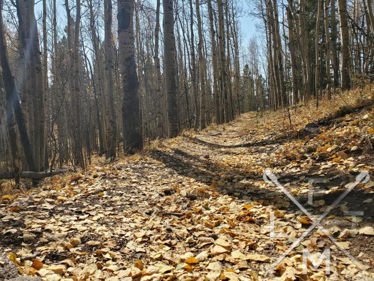
The Aspens
The middle of the hike is more rooted in forest and the trees thicken. You will also start walking through the Aspen Groves. We were about a week too late on this hike and most of the trees had lost their leaves but it did act like a gold paved trail for a bit.
The heavy forested section lasts for another two miles and actually gets a little flatter. While there are still grades in the teens there aren’t much in the way of steep climbs. Just a constant uphill but a good time to catch your breath a bit.
The trees are pretty thick and there isn’t much for views other than the forest except for one spot where there is a small trail leading through the trees down to a clearing which gives you views of all of the surrounding foothills to the southeast back towards Bailey.

The Last Push
At the 3.5 mile mark you will come to a sign that signifies the split in the trail. At this point to finish the out and back you will want to take the Cub Creek trail to the North-West (left) and you will begin another ascent.
The next mile gets a bit steeper and a lot rockier. You will have to gain 500 feet of elevation in just about a mile until you come to a clearing. The trail and the hike according to Alltrails continue past the clearing but there really isn’t much down that way. The clearing seemed to be the best place to stop.

If you do continue down the path you will be in another forested setting but it isn’t a well traveled path and the trail disappears a bit and gets hard to follow. I would probably stop at the clearing if i do this hike again.
Distance and Elevation
If you don’t have the AllTrails app you might want to check it out, I really love mine. It records your progress and is a great way to search for hikes that are nearby and gives you difficulty measurements. According to AllTrails today’s hike was around 9.13 miles and had a total elevation gain of about 2333 feet including undulations. That put my high point at around 11,264 feet. I was also moving for a total of 4 hours and 4 minutes.
I am a Pro member of AllTrails and love it. If you are interested in the platform, please consider using my affiliate link for AllTrails. It gives me a small commission with no extra cost to you.
Effort
This hike was harder than I thought it would be with a pretty consistent uphill walk. It wasn’t too technical though which did make it a bit easier. Here is the step count from my Fitbit.

Terrain
The trail starts with a sandy dirt trail before becoming more of a forest floor with rocks and roots for the middle part. The last third of the hike gets more rocky with some medium sized rocks that are loose and make it a bit slick especially on the way down. It is a constant uphill grade as well which makes it a little more challenging. I would suggest some good hiking shoes or boots.
Access
The trailhead is located on Prospectors Way off of Deer Creek near Bailey. Prospectors is a one lane dirt road that is moderate. There are some big pot holes. There is room for about 10 cars in the parking area and few cars were parked down the street as I was leaving. Restroom facilities are not available at the trailhead.
Wrap up
I really enjoyed this hike. I do wish that I had come about a week earlier in October to see the aspen trees in peak but the bare trees with all of the leaves on the trail made for a nice hike as well.
The hike was a lot steeper than I thought it would be and 2300 feet of elevation gain is nothing to shake a stick at. The elevation gain sneaks up on you because it is just a steady incline the whole time so make sure you are ready for that. There isn’t much technical to it until the last mile that gets a little rocky.
Overall a really nice hike on a Sunday morning and it was always nice to hike with my friend Alex, who we found is in a lot better shape than I am! If you like forests this would be a great hike for you too!
I have added this hike and all of the hikes I have done on my interactive map that you can find here. If you have a suggestion for a hike or any other comment feel free to email me at fatmanlittletrails@gmail.com or you can follow me on any of the below social media platforms. Happy Hiking!


