
| Distance | 3.94 mi |
| Elevation Gain | 282 ft |
| My Time | 1 hr 23 Min |
| Difficulty | Easy |
| Closest Town | Greeley |
| Food Nearby | Bulldog Pub and Grub* |
Pawnee Buttes Trail
Pawnee Buttes Trail is a hiking trail in Weld County, Colorado that features some really cool rock formations. It is located in the Pawnee National Grasslands and is open year round although there are sections that are closed from March 1st through June 30th for nesting birds. The hike is mostly easy so should be available for most skill levels but there are some makeshift stairs that could be problematic for some.
Getting Started
One of the hardest parts to the hike is just getting here! There is a 14 mile stretch of dirt county roads that you will need to take to get to the trailhead and I recommend some sort of mapping system. Once you arrive there are some picnic tables and restrooms and some information placards to help you on your way. The trail itself is pretty easy to follow and the hike is relatively easy as well so for the most part you can just follow your feet!
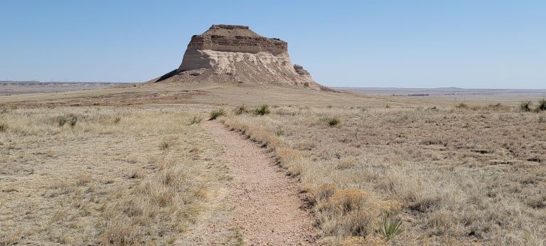
Early Views of the Pawnee Buttes
One of the first things that you see as you start the hike is how flat the surrounding area is. But then you notice the big buttes. I feel like an “I like big buttes” joke should go here. I digress. There is an early overlook trail to get a better view but it was unclear based on this map if it was open. So I didn’t take it, but it was hard to miss the East and West butte from the main trail.

I hiked in April and you can see how dry the area it is and how flat it is. Which is what makes the buttes so stunning in comparison. I do have to tell you that I am not a fan of the names East and West butte so I am going to call them the Tower and the Acorn from now on!
You can’t get to the Tower and Acorn without hiking between Lips Bluff and the Overlook first. After seeing the buttes, that is where I was headed!
The “Canyon”
The next step on the hike is to hike towards the fence and towards the two closer bluffs. Keep in mind that the only trail that is open during the nesting season is the one going right in between the bluffs. This trail will take you down a little ways between the bluffs which give the appearance of a a canyon. The descent is mostly easy as they have built stairs in the trail to make it easy to follow. Make sure to stay on the trail at all times so as not to disturb any nesting birds.

Inside this canyon between the bluffs you will get some good views of the walls standing above you. The trail is hard packed dirt and easy to follow. The trail continues through the mini canyon and out the other side where it continues on to the Buttes.

Trail to the Buttes
The next step after leaving the bluffs behind is to head towards the buttes. This part of the trail gave me a very Indiana Jones feel as it was a narrow dirt path that led to a formation that doesn’t look like it should be there!
Once you get out of the mini canyon you will be completely exposed to the elements. There is really no shade for the entire hike but the canyon does provide a little bit of support from the wind. The wind is traditionally pretty strong in this spot just a few miles south of the Wyoming border.
From canyon to Tower is roughly one mile of flat walking across these plains. As you get closer you really see how massive the “Tower” Butte is. The size is also exaggerated by having nothing else tall around it.

While you can’t get super close to the Tower you can get pretty close as you walk by. As massive as this rock is, as you get closer you can see how brittle it really looks! It almost seems like a sandcastle just waiting for a single wave to knock it down again.

Private Land
Between the Tower and the Acorn is a sign that states that you are now entering private land. While the trail continues closer to the Acorn, I decided not to proceed past the private land sign. I think it would have been fine as long as I stayed on the trail, I was by myself and didn’t want to chance it if I was wrong. Plus, the wind was howling on the open plain and I was ready to be done.
For those of you wondering why I call it the Acorn here is a picture from the private land sign. To me, it looks like an upside down acorn in the ground. I’m sure there are other opinions on this and I encourage you to leave me a message or comment below what you think it looks like.

While I could have taken that trail the rest of the way I feel good about my choice. I had read up on the nesting restrictions but wasn’t sure if they had separate rules on the private land. Everywhere else I have been the rule has been to stay on the trail on private lands but better safe than sorry. The Forest Service website also isn’t clear. It just says that the “second butte is on private land and to leave any gates in the state you find them”.
So I have no guidance to give on that. I will say that no matter the time of year, climbing on any of the buttes is not recommended. The sandstone looked very fragile and it was easy to see sections that had fallen or broken off. But if you are looking for a hike to some cool rock formations in the middle of a prairie this could be a good stop off.
Video
I put together this time lapse video of the hike so you can see the terrain and hiking conditions of the trail. I also am doing the time lapses in a new way that allows for the picture to be a little more stable. If you enjoy the video make sure to subscribe to my YouTube Channel. It’s free and you will get updates when a new video is available!
Distance and Elevation
If you don’t have the AllTrails app you might want to check it out, I really love mine. It records your progress and is a great way to search for hikes that are nearby and gives you difficulty measurements. According to AllTrails today’s hike was around 3.94 miles and had a total elevation gain of about 282 feet including undulations. That put the high point at around 5,305 feet. I was also moving for a total of 1 hours and 23 minutes.
I am a Pro member of Alltrails and love it. If you are interested in the platform, please consider using my affiliate link for AllTrails. It gives me a small commission with no extra cost to you.
Effort
There isn’t too much of a challenge to the Pawnee Buttes Main trail. The hike is mostly flat and in the sections where there are elevation gains stairs have been built into the trail. The most challenging part of the hike for me was the unrelenting wind. There is no shade or really anything but flat fields around the area so there are strong winds and bright sunshine the whole time on the trail.
Terrain
The trail is a dirt mix with some sections getting a bit sandy at times. The trail can also be a little challenging to keep track of when the grass is still in a dormant brown stage. It sort of all blends together. One thing to keep in mind is that there are seasonal closures of certain trails from March 1st to June 30th and only a single trail is available during those times. Please respect that as the closures are for nesting birds. A lot of the area is also on or near private property so it is important to stay on the marked trails only.
Access
The Pawnee Buttes Trailhead is one of the more challenging trailheads I have tried to find and I strongly recommend a mapping system of some sort. To get to the trailhead the last 14 miles of the trip are on dirt county roads. This roads are in pretty good shape but how good varies with each road. The final mile long trail to the trailhead is a single lane dirt trail. While you don’t need high clearance for any of these roads, there are a lot of rocks on the road and the roads can become a little slick. The trailhead has picnic tables and pit toilets available and parking for about 20 cars and some long vehicle parking for trailers.
Wrapping Up Pawnee Buttes
I am a little torn on Pawnee Buttes. It is a really cool experience, especially for someone who hasn’t seen something like this before. To see these two giant Buttes coming out of the middle of the grasslands gave me a throwback to famous Devils Tower. However, it is kind of in the middle of nowhere and not the easiest to get to for such a short hike.
Part of my concerns are that I think I came at a bad time. Half of the trails were closed for the nesting and the grasses hadn’t grown yet and were still in a bit of a dormant stage. I think it could have been a completely different experience if I had come in the summer with long green grass all around.
Overall I enjoyed my time and the hike was enjoyable although it was a little short. If you have never seen something like this and are in Northern Colorado or Southern Wyoming, I think it is worth a trip. It was also my first hike in Weld County bringing my Colorado Counties hiked in total to 25 I think. Which is exciting.
I have added this hike and all of my hikes to my interactive map page that you can find here. If you have a suggestion or comment you can email me at fatmanlittletrails@gmail.com. Or follow me on any of the below social media platforms. Happy Hiking!
Gallery from Pawnee Buttes


Pingback: Bulldog Pub and Grub - Greeley - Fat Man Little Trail
I loved read this! I grew up in Grover – the small town close to the Buttes and went often. You are correct, the wind is relentless, no matter the time of year. There isn’t really much grass, even in the summer, as it is incredibly arid and dry. It is a very interesting place, even though it is a bit of a challenge to get there. I’m glad you were able to visit!
I really enjoyed it there! It kind of just popped up out of nowhere and was a wonderful surprise!